

CNN
—
Incoming heavy rain from an atmospheric river-fueled storm that slammed into the West Coast early Wednesday is threatening mudslides and debris flows in Southern California and has already prompted evacuations in the Los Angeles area.
But that’s not all this storm is capable of — its reach and impacts will only get more extreme as the week continues.
The cross-country storm will strengthen into an unusually intense March powerhouse by the end of the week and will put millions at risk of wildfires, severe thunderstorms, tornadoes, powerful wind gusts and blizzard conditions.
Here’s what to expect each day:
Wednesday: Storm soaks West Coast, brings debris flow threat to Southern California
Rain began in the Pacific Northwest and showers dotted Northern California well before sunrise as the storm pushed onto the West Coast. Soaking rain and mountain snow will begin in Northern California by the afternoon and spread south.
Heavy rain will reach Southern California later in the evening and will ramp up the threat of flooding overnight and into Thursday.
A level 2 of 4 risk of flooding rainfall is in place from Santa Barbara to Los Angeles, including areas scorched by the Palisades and Eaton fires, according to the Weather Prediction Center. The storm’s relatively quick pace could help limit widespread flooding in California, but recently burned areas remain at a higher risk for flooding and debris flows.
At the direction of Gov. Gavin Newsom, state agencies have deployed more than 400 personnel to prepare to respond to the storm.
Evacuation orders are in effect for about 120 homes deemed to be “vulnerable properties,” mostly near the Palisades burn scar, as well as a handful of people in the Hurst fire area, a Los Angeles Fire Department spokesperson said.
Officials issued additional evacuation orders Wednesday for more than 1,700 people in and near Sierra Madre’s Eaton Fire burn scar, according to the fire department.
Evacuation warnings were issued for other parts of Los Angeles County Tuesday due to the risk of debris flows from the Palisades, Eaton, Franklin and Kenneth burn scars, according to the county’s emergency alert service.
Warnings urge people in and near these burned areas to prepare to evacuate at a moment’s notice while orders are a command to evacuate immediately.
Evacuation warnings were also issued for parts of San Bernardino County Tuesday, according to the county sheriff’s office.

A span of the Pacific Coast Highway will close from eastern Malibu to just east of Will Rogers Beach beginning noon Wednesday due to the risk of debris flows and flooding.
Heavy snow and strong winds will also make travel very difficult or impossible in California’s Sierra Nevada, especially by Wednesday night.
Thursday: Snow, rain and wind expand over the West
The storm will push east, with rain and snow spreading into more of the West and reaching much of the Rockies by the evening.
Places in the mountains could see half a foot or more of snow, with a few inches also falling at lower elevations and potentially in some valleys.
By late afternoon, widespread strong winds will begin from Nevada and Arizona to the Rockies with wind gusts of 40 to 50 mph possible – especially in mountainous terrain – as the storm starts to strengthen. These wind gusts, combined with rain and snow, could create hazardous travel conditions.
Gusty winds will also impact the Plains ahead of the storm and ramp up a widespread fire threat, especially from the late afternoon onward. More than 800 miles of the central US, from western Texas through Nebraska, are under a level 2 of 3 fire weather risk, according to the Storm Prediction Center. Any spark could turn into a wind-driven blaze in these conditions.
Wet weather will continue in California and the Pacific Northwest for much of the day, easing up over time. The snow in California’s highest elevations will be the slowest to end, with multiple feet falling in the peaks of the Sierra Nevada by the time the storm moves on.
A few feet of additional snow will help the Sierra Nevada snowpack, which is hovering at 81% of normal, according to data from California’s Department of Natural Resources. Snowmelt from a robust snowpack is critical for filling reservoirs that feed the state’s water supply during the dry season, which typically stretches from May to September.
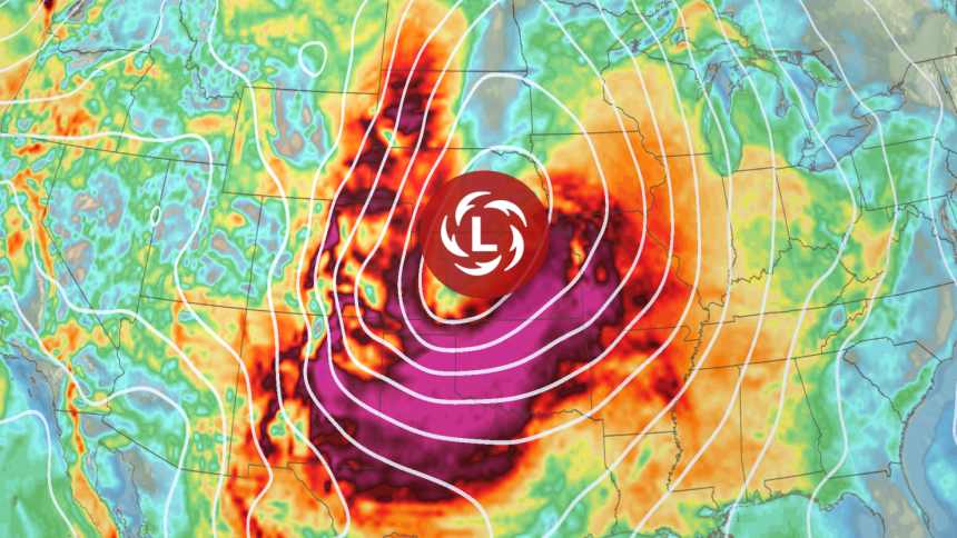
Friday: The storm intensifies, dangerous severe thunderstorms begin
The storm will strengthen quickly and become quite intense while it tracks into the Plains, setting up a repeat of last week’s severe thunderstorm threat, widespread strong winds and increased fire danger.
Strong winds that could disrupt travel and damage power lines will whip across the central US, turning from breezy in the morning to fierce by the day’s end.
Widespread gusts of 40 to 50 mph are likely by late afternoon, with stronger gusts past 65 mph possible from New Mexico and Texas through Oklahoma and Kansas. The winds will increase fire danger in eastern New Mexico and the Southern Plains to the extreme. Dozens of fires flared up in Texas last week under similar conditions.
Severe thunderstorms will roar to life by the late afternoon in the Mississippi Valley as the powerful storm’s potent cold front clashes with a surge of warm, moist air from the Gulf.
The thunderstorms will become more ferocious and expand by the late evening to pound potentially more than 900 miles of the Mississippi Valley – from Louisiana to Minnesota – into the overnight hours.

“All severe hazards are possible, including swaths of intense winds and tornadoes,” the Storm Prediction Center warned Wednesday.
A level 3 of 5 risk of severe thunderstorms is in place from Mississippi through much of Illinois, according to the center. Thunderstorms in this area could unleash wind gusts stronger than 75 mph – equivalent to a Category 1 hurricane. Strong tornadoes – rated EF2 or higher – are also possible.
These hazards will take on another layer of danger once it’s dark and difficult to see: Nighttime tornadoes are nearly twice as likely to be deadly as those occurring during the day, a 2022 study found.
Saturday: Severe thunderstorms, blizzard conditions hit the eastern US
The intense cross-country storm will expand into more of the eastern US with severe thunderstorms and blizzard conditions.
Severe thunderstorms could be ongoing in the early morning, especially in parts of the Ohio Valley.
Some of these storms could become less intense by the afternoon but the threat won’t end there – another round of dangerous storms will surge to life in the afternoon along the Gulf Coast and in the Southeast.
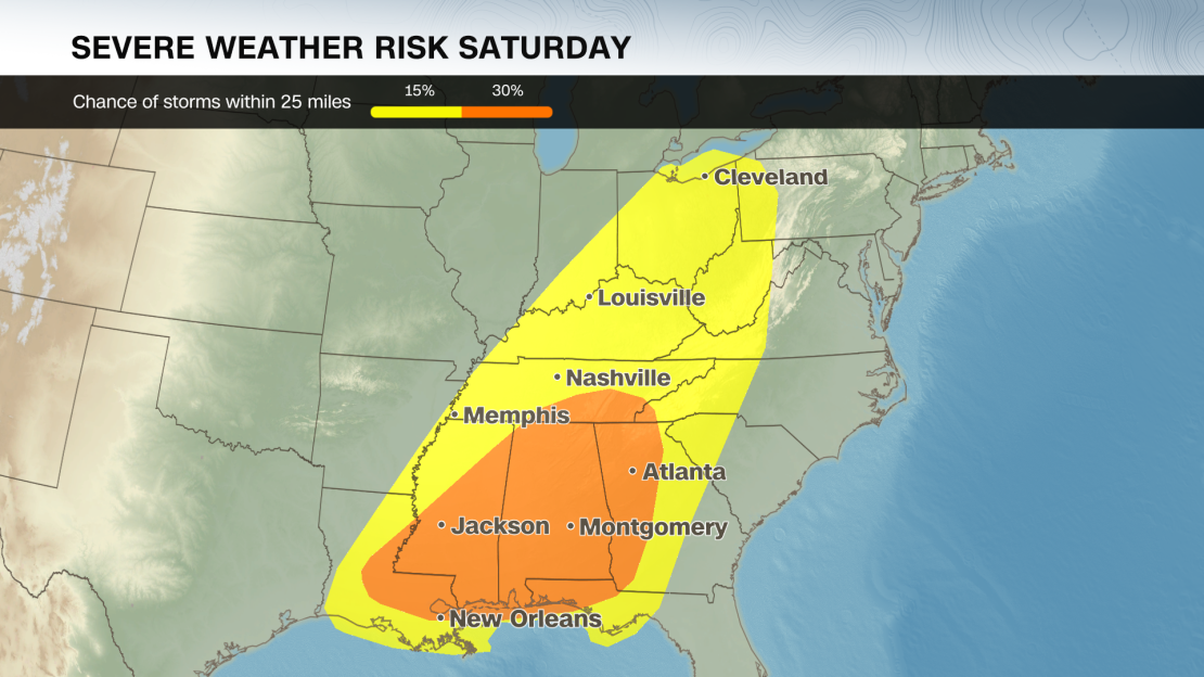
Damaging wind gusts, hail and tornadoes will all be possible. These storms will also dump heavy rain that could cause flash flooding, especially from Mississippi to northern Georgia and north into Kentucky.
Snow, ice, rain and strong winds will slam the north-central US starting in the earliest hours of Saturday morning. The combination could cause periods of blizzard conditions – blowing snow that makes it difficult or impossible to see more than a few feet.
Last week’s storm created a blizzard that shut down highways, stranded vehicles and caused crashes across multiple states.
The storm’s widespread, powerful winds will ease up over the Plains through Saturday and move farther east.
Sunday will likely be a wet and stormy day for much of the East Coast. Some severe thunderstorms with strong winds will persist through Sunday but will likely be less intense than Friday and Saturday’s storms.
CNN’s Stephanie Elam and Elizabeth Wolfe contributed to this report.