New rounds of severe thunderstorms are underway and life-threatening, potentially catastrophic, flooding risks are brewing in the central and eastern United States Tuesday, putting more than 50 million people at risk of dangerous weather this week.
The threats come on the heels of Monday’s storms, which unleashed damaging wind gusts, hail bigger than baseballs and tornadoes.
Storms Tuesday morning prompted severe thunderstorm warnings across six states as well as a flash flood warning for Oklahoma City. More of the same is expected to unfold as multiple rounds of storms move through the Southern Plains, Mississippi Valley and Northeast into the evening hours.
A massive, 1,800-mile stretch of the US from West Texas to Vermont is within a level 2-of-5 risk of severe thunderstorms on Tuesday, according to the Storm Prediction Center. Two smaller but more significant level 3-of-5 risks are in place for parts of Ohio, Pennsylvania and New York and parts of Texas and Oklahoma.
The first round of storms Tuesday morning impacted areas from northern Texas to southern Kansas and then pushed east into Missouri.
A powerful line of storms in southwestern Missouri sent wind gusts up to 90 mph roaring through Springfield and produced a few brief tornadoes in nearby areas. Fierce winds brought down trees and power lines, leaving more than 60,000 homes and businesses in the state without power as of Tuesday afternoon, according to PowerOutage.us.
Another round of storms started up in the early afternoon in parts of Oklahoma and Arkansas, while a separate area of thunderstorms unleashed up to 70 mph wind gusts in Indiana and Ohio – where more than 50,000 customers were without power late Tuesday afternoon.
Additional strong to severe storms are possible throughout the day, with the strongest storms possible by the evening in the Southern Plains.
Storms in this area could produce large hail, damaging winds and tornadoes. They could also dump rounds of heavy rain, putting the risk of dangerous flooding on the table in what forecasters warn could become a multi-day flood event.
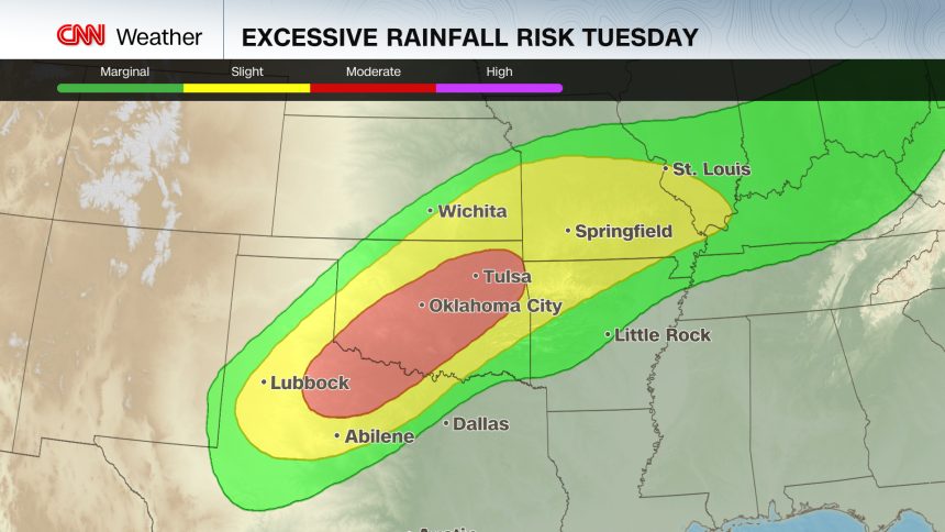
A level 3-of-4 risk of flooding rain is in place for parts of northern Texas and much of Oklahoma – including Oklahoma City and Tulsa – according to the Weather Prediction Center. The area is primed for widespread flash flooding that could become life-threatening in some instances, the WPC warned.

Rounds of heavy rain over the past few weeks have drenched the ground and made it vulnerable to flooding as the soil won’t be able to soak up any excess moisture. In Oklahoma, flash flooding from storms the weekend prior prompted high-water rescues and left at least five people dead.
Flash flooding was already ongoing in the Oklahoma City area Tuesday morning, and the situation will only deteriorate there and in nearby areas as additional storms hit the area.
Southwest Oklahoma could experience “locally catastrophic” flooding, the National Weather Service warned.
Storms were also developing farther north Tuesday afternoon in parts of Ohio, Pennsylvania, New York and even as far as Ontario, Canada.
Damaging wind gusts are the main threat with these storms, but some could drop large, egg-sized hail and tornadoes through the evening.

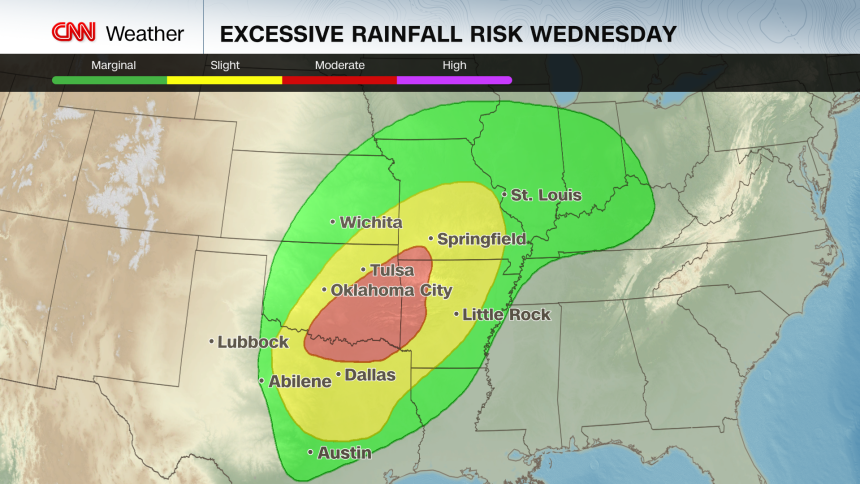
Stormy weather and periods of heavy rain will persist Wednesday, with a level 3-of-4 risk of flooding rainfall in place for parts of Texas, Oklahoma, Missouri and Arkansas.
A few severe thunderstorms are possible in the Southern Plains on Wednesday, but widespread chances of damaging storms fade for the rest of the week.

