CNN
—
A series of atmospheric river-fueled storms are pounding the West with powerful winds, drenching rain, heavy mountain snow and churning up massive waves and dangerous seas just off the coast.
The seemingly never-ending series of storms began over the weekend but turned deadly early this week in California.
A man died Monday morning after being trapped under debris in Sunset State Beach in central California, The Associated Press reported. A large wave likely pinned him there, according to the Santa Cruz County Sheriff’s Office.
Another man was likely swept out to sea just a few miles south at Marina State Beach early Monday afternoon, authorities said. The US Coast Guard and California Highway Patrol were deployed to search for the man by air and sea but could not find him, according to the Marina Police.
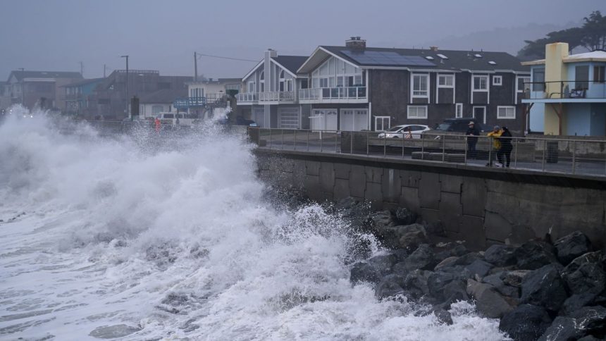
Waves were around 10 feet high in the Monterey Bay area – where both incidents took place – from late Monday morning into the early afternoon, according to data from NOAA. Waves as high as 25 feet were reported elsewhere near the coast of northern and central California Monday.
The storm expanded its threats Tuesday as heavy rain deluged the northern half of California, including San Francisco. Rainfall rates could reach 3 to 4 inches per hour during the heaviest rain Tuesday, mainly in the Sierra Nevada foothills, the National Weather Service warned.
Torrential rain could create flash flooding and debris flows, especially across burn scars in the area. Burn scars are often a combination of burned plant life, debris and an altered layer of soil, which make them prone to flooding.
Heavy mountain snow will fall through Tuesday in the higher elevations of the Sierra Nevada and parts of the Cascades where winter weather alerts are in place. Widespread snowfall up to a foot is possible with isolated totals potentially exceeding a foot.
Along with snow, widespread wind gusts of 70 mph with isolated gusts across ridges potentially reaching 90 mph could cause blowing snow and reduced visibility to any travelers.
This storm is also whipping up winds elsewhere along the West Coast, where high wind alerts are in effect. Widespread wind gusts to 60 mph could cause power outages on land and are already amplifying dangerous waves off the coast. Waves up to 35 feet could cause coastal erosion and damage to coastal communities this week.
“Life-threatening swimming and surfing conditions and significant shoreline erosion can be expected,” the NWS warned. “Large waves can sweep across the beach without warning, pulling people into the sea from rocks, jetties and beaches.”

Pier crumbles into the sea
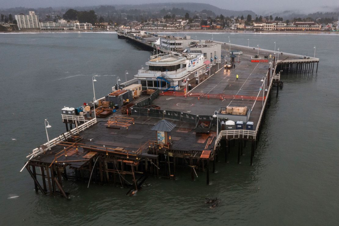
A dramatic collapse of a section of the Santa Cruz Municipal Wharf on Monday afternoon underscored growing challenges posed by climate change and the urgent need for public safety measures.
Around 12:45 p.m. Monday, the end of the wharf, about a 200-foot portion, collapsed into the Pacific Ocean, along with three workers, a closed-down restaurant and a closed public bathroom facility, Santa Cruz city officials said Tuesday.
That portion of the wharf and the city’s iconic Dolphin Restaurant had been closed to the public for construction since last December, following significant damage caused by previous storms.
As powerful waves fueled by high tides and windy conditions beat against the wharf Monday, the active construction site collapsed into the ocean. The rest of the wharf is intact, officials said.
Two of the workers who fell into the water were rescued by a lifeguard unit, and the other person self-rescued, assistant city manager Michelle Templeton said Tuesday.
The city was expecting the large ocean swell this week and had deployed eight additional lifeguards, some of whom were patrolling the water on watercraft when the incident occurred, according to Ryan Reber, chief of operations for the city’s fire division.
“This isn’t what we thought was going to happen, for sure, but we were prepared and we were in the water already, so it was a quick deployment and a quick rescue for us. We had this on our radar,” Reber said.

The collapse, attributed to the relentless force of the ocean, has left significant debris, including pilings and sections of the deck, posing serious hazards to navigation and public safety. The incident was “another testament to the power of our changing climate,” City Manager Matt Huffaker said.
Officials are asking the public not to attempt to retrieve any debris remaining in the water.
Back-to-back storms last December caused the initial closure of the wharf and prompted a $4 million dollar restoration project, which is ongoing, city officials said.
“As many people know and see on a daily basis here in Santa Cruz, climate change has been bringing on more intense storms, coupled with sea level rise, and with that, the city continues to face growing challenges that threaten Santa Cruz’s infrastructure and coastline,” Templeton said.
Santa Cruz Mayor Fred Keeley said the city will need to address those broader challenges going forward.
“I don’t think we’re by ourselves. I think this is what coastal communities around the world are probably dealing with in that manifestation of climate change,” Keeley said Tuesday.
As the city braces for more severe weather, officials urged the public to heed high surf warnings and steer clear of the beaches. “Our coastline is wild. It’s unpredictable,” Huffaker warned, urging vigilance during the holiday season.
More storminess ahead for Christmas and beyond
The storm slamming the West Coast will move east Wednesday and could bring up to a foot of snowfall across the Rockies, just in time for Christmas Day and the start of Hanukkah.
It’ll eventually move into the Southern Plains Thursday, where its threat will shift once again, this time to severe thunderstorms. The strongest threat of severe storms could encompass eastern Texas and northwestern Louisiana Thursday afternoon, where a level 2 of 5 risk of severe storms is in place, according to the Storm Prediction Center.
The West Coast will only have a short break from storms before another atmospheric river-fueled storm begins to lash the coast by Wednesday evening, bringing a prolonged round of coastal and lower-elevation rainfall and higher-elevation snowfall through the weekend.
Rainfall totals of 5 to 10 inches are possible through late in the week, which could lead to additional flooding and rising river levels. Feet of snowfall could bury the area’s higher elevations and wind gusts up to 65 mph could bring life-threatening conditions to travelers, the NWS warned.
CNN Meteorologist Mary Gilbert and CNN’s Karina Tsui contributed to this report.


